Living Lakes Canada found south-facing watersheds in the basin at higher risk of running low on water amid hotter, drier summers
Evert Lindquist
Jul 14, 2025 4:40 PM
Conserving water is becoming more important for West Kootenay communities as changing climates alter watersheds in the Columbia River basin, an analysis by a Nelson-based NGO reveals.
In June, Living Lakes Canada (LLC) released a new Watershed Bulletin that analyzes Environment and Climate Change Canada data and puts the focus on how smaller watersheds in the region are impacted by human-caused climate change.
While snowmelt historically provided a steady stream of water around late summer, communities have run low in recent years amid earlier spring heat, less summer rain and longer heat waves. This makes LLC’s latest findings, such as how south-facing watersheds have lower resilience and water security, important for Columbia basin residents.
“Data-driven insights can help assess drought potential in small watersheds, develop adaptation strategies, and inform smarter, more adaptive water management,” LLC stated in a release. “Not all watersheds respond the same way to drought or warming, which highlights the need for tailored approaches to climate-ready planning across Southeast BC.”
Arlo Bryn-Thorn, LLC’s program manager for the Columbia basin network, said a big trend from these findings is that the rate of water availability later in summer is changing due to longer drought and shorter periods of low streamflow.
“Understanding the dynamics in each of our watersheds is important,” he said. “This bulletin, I think, really highlights the importance of monitoring these smaller watersheds.”
It hones in on eight Columbia basin watersheds, which range in size from four to 64 square kilometres. North-facing ones such as Upper Glacier show “promising resilience” due to less direct sun exposure, Bryn-Thorn said, but more south-facing ones such as Dumont and Carlyle have struggled.
While the high-elevation Upper Glacier watershed is coolest and releases most of its annual runoff from June to August, the low-elevation Dumont watershed is hottest and releases most of its water by May — leaving almost none available for summer. That raises red flags for communities relying on it, because similar-sized watersheds in the West Kootenays generally release 80 per cent of their runoff much more gradually from April to September.
For the higher-elevation Carlyle watershed, LLC reports that it’s shedding 90 per cent of its runoff a month earlier than it did 11 years ago, which suggests that summer heating is accelerating snowpack loss.
“This trend is concerning because it suggests that less water may be available later in the season when it’s most needed for sustaining aquatic ecosystems and meeting community demands,” the bulletin says.
Wildfires are further complicating these water resources for communities. Increased sediment from fires, for example, can enter watersheds and impact the food chain by causing algae blooms and blocking out oxygen, Bryn-Thorn explained. Landscapes touched by fires may also suffer from altered hydrology and a loss of vegetation that would help store water for drought.
The good news is that “north-facing, high-elevation watersheds may still be relatively unaffected (by summer heating) and able to contribute to late-September and October flows,” the bulletin says.
As well, LLC is helping communities and their emergency responders map water sources ahead of wildfire emergencies.
This work, funded in part by the Columbia Basin Trust, has already been carried out in past fire seasons and has already made a difference. BC Wildfire Service (BCWS) utilized maps developed by LLC and the Argentina Safety and Preparedness Society in its response to the July 2024 Argenta Creek fire, cutting down the field reconnaissance time normally required.
“This is a practical tool that could make a difference in response,” BCWS senior wildfire officer Jeremy Angus said in a release Monday, July 7.
“When a wildfire breaks out, there’s no time to search,” added Michelle Griffiths, program coordinator for the Slocan Integral Forestry Cooperative. “Knowing exact locations of reliable water access points and sources can mean the difference between containment and catastrophe.”
LLC’s proactive mapping work will continue through this summer and is expected to produce reports and maps in 2026. Currently, it’s asking members of the public to complete a short online questionnaire to provide local knowledge of water sources, including creeks, standpipes, hydrants and access routes.
“This on-the-ground information, often missing from existing emergency response systems, is combined with scientific water data to create detailed, interactive maps,” the release adds.
Those interested in contributing knowledge can visit livinglakescanada.ca/project/water-resource-mapping-to-support-wildfire-response.
“There are many things that many of us can do to conserve our water,” Bryn-Thorn added, pointing to rebate programs in municipalities across B.C. that help homeowners finance rain barrels and high-efficiency faucets.
Advocacy and household emergency preparedness are other parts people can play, drawing more awareness to how changes to watersheds may impact future water availability, and what resilience can look like for affected communities.
In the wake of LLC’s findings, the Ministry of Water, Land and Resource Stewardship announced Monday, July 14, that residents across B.C. should prioritize conserving water this summer as drought risk rises.
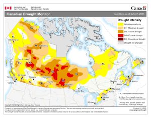
“Much of the southern Interior is expected to remain dry with little to no rainfall, with drought conditions worsening and stream flows continuing to decline in the Nicola, Kettle, Okanagan and Slocan-Lower Columbia basins,” the ministry said in its release.
Residents are asked to water their lawns less, not use hoses to clean driveways and patios, turn off the tap while brushing their teeth and washing dishes, and fix leaky faucets.